Traditionally, cache machines start early in the mornings around 5:30-6:00 a.m. and I knew Ben wasn't going to get up that early, so I made him get up around 8 and ready and out the door by 9. We got dressed, grabbed our breakfast and packed up our stuff we would need for the day. Due to our hotel room situation, adding the extra night may have affected our stay there, so we called and asked if we had to move rooms or not. They didn't answer, so we left hoping for the best.
We left the hotel around 9:10 and I had Ben drive while I navigated us around town. I was so happy the weather held up and it wasn't raining. We filled up at the Sinclair because it was closest to our hotel and gas is cheaper in Idaho than it is in Washington. I kinda miss living near a state border where gas is cheaper on the other side. Oh well. We took advantage of it while we were there that weekend.
Based off of where we were, I quickly figured out a route so I could get Ben around town without a lot of backtracking. I have mentioned before that I have been to Lewiston but not in this capacity. I was going to learn a lot more about Lewiston and visit places I've never been to on this trip. This is one of the reasons why I love geocaching...visiting and learning about new places.
Our first cache of the day was called Rod Stewart (GC8YZXB). It was located on the edge of a very large parking lot overlooking the town down below. We thought that are was probably a shopping center at some point but now it's a little run down and features a dilapidated K-Mart. Ben and I made quick work of it. I knew we were probably looking for a rod of some sort. I saw a suspicious piece of rebar sticking out of an old parking block. It helped having found others like this in the past. We got our names on it and moved on to the next.
The Internet (GCA5FXJ) was an interesting one. Ben and I got to the parking lot and had to walk down a small geo trail over some broken rocks to the ammo can. We had to figure out a code to open the lock. Once we got inside, we signed our names and locked it back up. We walked back to the Escape. I looked at the app to see which cache was next.
The next one was up by the county airport. Community Events #2 (GC207ZT) was at a large sign that gets changed out depending on what time of year it is and what they are advertising. There was plenty of room to park and search. We honestly had no idea what we were looking for. We checked every nook, cranny, crease and even counted everything to make sure each side of the sign was even. About 15 or so minutes into the search, I started reading logs of past finders to see if I could get a hint. I really couldn't get one. I took a step back and really looked at the sign and its surroundings. Then I saw something. Ben! You're tall, grab this bar and see if it moves. It did. I had Ben get it down so we could get the cache out of it. We got our names on it, took a few pictures and struggled putting it back how we found it. It was a tight fit.
From there, we grabbed, ??? (GCAECEX), Shave and a Haircut... (GCA2127), Power of Love II (GC94P5H) and Don't Take Offense (GC8VYK5). All of those caches were quick park and grabs.
We went to our first and only letterbox, MCRD Lewiston (The TB Recruit Training Center) (GCA8C02). It was a true letterbox. We had to go to a waypoint to get coordinates to a final. You kinda already knew where the final was because it was big, yellow and obvious. I followed the instructions, opened the lock and saw all the commotion that was happening inside the cache. You could tell this was designed by a person who loved the military or was once in the military. I didn't take nor leave anything, but I signed the logbook and took a few pictures.
Power of Love (GC94P5H) was at the fairgrounds. We pulled up in the Escape and I got out to grab the cache. It was a clever one made out of PVC pipes. I took it into the Escape with me so we could look at it and sign the logbook. I got out to put it back and a couple in a truck that had gotten out to be out in the field, about 50 yards away, were watching us like we stole something. They both looked at us, the woman immediately got on her cell phone like she was calling the cops on us and lurched ran at us. We thought it was odd. We flipped them off as we left the fairgrounds.
We finished the caches in that area and got back onto Thain Road. Ben said that we should find somewhere to use the restroom soon. I saw a Burger King and pulled into the parking lot. Ben went inside while I stayed out by the Escape and made us each a PBJ for lunch...since it was about that time. Once he was done, we grabbed our sandwiches, chips and drinks and figured out what part of Lewiston to hit up next.
We drove back down to where our hotel was to get Waterfall of Memories (GC1RTB4), it had about 75 favorite points. We parked and followed the path to where the coords took us. The area was dedicated to the people who passed away while fighting for our country. They had a waterfall, paths and small bridges. It was a nice memorial. I found the bison tube hiding on the small metal bridge. I got our names on it, took a picture and hid it back in its hidey hole. We got back to the Escape and drove over to the train on the other side of the intersection.
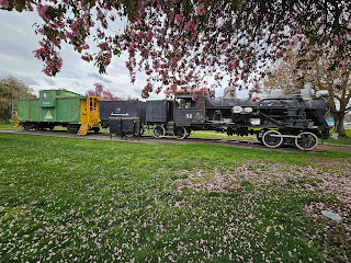
There was a place to park, which was nice, we got out and inspected the train for the answer we needed for the virtual cache, All Aboard (GCAJFVE). We finally found what we were looking for, took a couple pictures and got back into the Escape. This cache was not part of the cache machine, but because it was a virtual cache, I wanted to get it anyway.
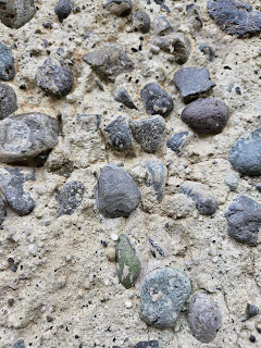
We looked at the app to see which one was next on our list. We followed the road along the Clearwater River to the northwestern part of Lewiston near the border of Washington and the confluence of the Snake River for two caches. The first one was called Rock On (GC6J870), and it had a lot of favorite points. We also saw that it had a difficulty of 4. We could be here a while looking. We found a place to park and started looking. It was a cement/rock building next to the water and of course, there were people fishing nearby. We would have to find the one rock that comes out of the wall, but it was camouflaged so well! We searched every square inch of that building and just could not find it. I scoured the found it logs on the app, studied the photos other cachers had posted...we just could not find it for the life of us. Then I thought of another way to hunt for it, and it paid off. I found the darn thing. Once you saw it, you knew it looked different from the others. We got our names on it, took a few photos and put it back. That was a well-done cache.
We moved onto the Lewis and Clark Information Center to grab the other two, Nano at the Confluence (GC90CJE) and a virtual cache, Tsceminicum (GC9F28), an oldie from October 2002. We ran into a cacher named PIR359. We chatted for a bit while Ben and I got our picture in front of the statue to suffice the virtual cache. Then we walked back to the Escape since there was a weird homeless man hanging out in the structure next to the river.
We drive across the bridge and back into Washington. We spent the rest of our day in Clarkston grabbing caches along the route. We picked up No Parking at Anytime (GC7TKGW), Eagle Project (GC4MT57), Squirrely (GCA93TE) and Ode to Team MD (GC2BBKJ). I decided that since we were already on this side of the river and I needed Asotin for the Towns and Cities Challenge, that we might as well grab it than wait until the next day. Ben agreed.
I navigated Ben to Something's Fishy #2 (GC23RXF). There was a large gravel parking lot filled with cars. Across the street, a fastpitch game was being played by the local high school. We found a place to park in the lot and walked along a trail next to the Snake River to one of my Towns and Cities geocaches I needed to finish the challenge. There were old cement structures, boulders, logs and brush to walk around. I found the log that it was hidden inside of, pulled it out and signed our names. I was happy to finally cross another one of the Towns and Cities caches off my list! We got a few pictures before rehiding it and walking back to the Escape.
We left Asotin and drove north back towards Clarkston. We stopped and got Red Brick (GC3RACA) Muley (GC3V942) and Yuma Micro (GC3RACZ) and took two trackables out of that one so they could move along on their journey. These caches were quick park and grabs.
From there, we got onto Hwy 12 and drove west to pick up 11th Anniversary (GC2VJ1V) along the highway. We had to park as far over as we possibly could on the road while I got out and hustled across the street avoiding oncoming traffic. I was able to find the container quickly, got our names on it, placed it back in its hiding spot and safely ran back across the road and into the Escape.
I directed Ben to the next few, Not All Nests Have Birds (GCA49G3), Great Place Fore a Tee (GCA4BVD) and Where the Deer and Pheasant Roam (GC237C6). All were located within the Chief Timothy Habitat Management Unit being operated by the US Army Corps of Engineers. It is a 72-acre swath of day-use land where you can hunt, fish, and hike. We had the place to ourselves. Each cache, we had to walk at least a quarter of a mile to from the parking areas. We were here for about an hour while we grabbed these three caches. I also brought a bag with me so we could pick up intact pinecones for wedding decorations. We managed to fill up an entire bag.
We finished our walk and saw how much time we had left until it got dark and the Cache Machine event, which started at 7:30. Ben and I thought we could get about 3-5 more caches depending on how long they took to get.
We got back onto Hwy 12 and continued west. We stopped to get Silly's Travel Bug Trading Post (GC361FV). We got off the highway and found a small dirt driveway to park in. Ben stayed in the Escape while I hopped out to go get it. I saw several pheasants running around the tall grass trying to get away from me. It took me to a tree with an old, deformed metal piece in it. The large cache container was underneath the metal piece. At least it kept it dry during the wet times of the year. I signed our names, grabbed the TB to move on and put it back. I walked back to the Escape.
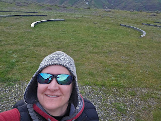
I wanted to get one more cache out that way, we were about 9 miles west of Clarkston, so we drove into Chief Timothy Park/Silcott Island, in the middle of the Snake River. We did not have the permit we needed, so Ben stayed in the Escape while I hustled out to get the virtual cache, Listening Circle by Maya Lin (GC7B7G9). It was about a half a mile out and back. I got the necessary pictures I needed and met Ben back at the Escape. He said since we were here, he needed to use the restroom. We drove down to the restroom and we both utilized it. I saw there were also good pinecones there, I got out and picked up a bunch of them and stuffed them into our other plastic bag. Yay wedding planning!
We got back onto Highway 12 and went east back into town. We got into Clarkston and went over the bridge back into Lewiston. We wanted to grab a couple more. We found a place to park in downtown and walked to the center of town for Lewiston's Muggledbury Square (GC9V64X). This one took us a few minutes to find because the coords were taking us all over the place. I finally just started looking in the obvious places and finally found it. It was an electric faceplate hidden in plain view but if you didn't know it wasn't supposed to be there, you wouldn't have noticed it. I got our caching names on it and then we went weird with the statues.
We decided to walk to the next one. We should have looked into it more before we scaled the side of a hill to get to it. Of course, there is an easy way and a hard way. We chose the hard way in and the easy way out. I thought Why Not Sit a Spell (GC9NE12) was along the hillside trail based on the map. Haha, it wasn't. We scaled the steep hillside trail anyway. When we got to the top, we found out it was a park, and you could drive and park in the parking lot. Ben was like, lame. We found the cache fast, got a picture of Ben being a goof and walked back down to the Escape along the street.
It was about 5:30 and we were getting hungry. We really didn't want to eat at the cache machine venue because it takes too long to get food. So, we decided to go to Cee Cee's, a Mexican joint Brad told us about the night before. He said he eats there often during the work week. We arrived at the restaurant, parked and went inside. We were seated right away in the back. I ordered a water, and Ben got a beer as we looked at the menu. Ben ordered a wet burrito, and I thought the tamales looked good. Our food came out quickly and we both devoured our food. It was delicious just as Brad described. We paid and headed over to the event.
Lewiston ID Cache Machine Dinner (GCAMWGK) was at KC's Burgers and Brew off of Thain. The place was so popular there hardly were any parking spots left. I told Ben we made a great choice to eat dinner elsewhere. We found some places to sit, talked to some people we knew and didn't know. One of the cachers from Idaho gave out some Idaho potato pins...I thought that was cool. We signed the logbook and listened to some information about the next couple cache machines, ones we would probably not be able to go to because we would be busy. We stayed for about 45 minutes.
I wanted to stop by Rosauer's to see if they had any good beer that I couldn't find at home. I did find a six pack of huckleberry ale, so I bought it and walked back out to the Escape where Ben was waiting for me.
We headed over to the western side of Lewiston to Groundworks Brewing. Ben and I try to visit at least one brewery when we travel around. This was a smaller brewery with a view of the Snake River. We found a place to park, and we went inside. There were a few people there enjoying their beers. We both ordered the Down Under Blonde and played rummy as we drank our beers. We stayed for about an hour.
We got back to the hotel around 9:15 and had to talk to the Grand Hotel desk to make sure our room situation was fine, they said it was. It was a relief. We brought our stuff into our room, got situated, got in some showers, watched TV and relaxed a bit before bedtime.
Notes on the Day:
We found 40 caches.
We crossed off Asotin and now I have 8 more towns and cities left to go.
Next Adventure: Lewiston to Lacey


No comments:
Post a Comment