Saturday, July 27

WSGA Campout 2013

I’ve always wanted to go to a WSGA campout.  I tried going to the one last year but that wasn’t going to happen.  It was too far north, I didn’t have the money or the vehicle to get me there.  I knew it had published so in January I put a maybe on the will attend log.  I had no idea what Bob or Bev would want to do and not sure if my mom would want to go with me.  For months I tried to figure it out.  While I was with Brenda and Ray on the ET Highway, they told me a little bit about what they had planned and where exactly it was going to be. 

The day got closer and closer.  Many things came up.  I knew around May I would not be able to camp but maybe pull off a day visit on the Saturday.  It would have been fun to camp.  The day got closer and closer and I almost could not go because of a yard sale that almost happened but didn’t.  Mom had Saturday sew but planned not to go but to help a co-worker move but she ended up not needing help.  She went with me instead.

Doug came home for the weekend and ended up going with dad and grandpa to Oregon to help at the Dexter rental.  Mom and I did a few chores before heading down to the Columbia Gorge.  I downloaded a query that followed Hwy 14 from the event out.  It didn’t quite make it to Washougal and Camas.  We didn’t go down there to get a ton of them but to get certain ones that would fill in my cities and towns challenge.  I am getting close to being done.  51 more to go! 

I knew we had a lot of time to get down there.  According to the Nuvi, we would be there sometime around 1:15.  If we stopped, time would be added accordingly.  I needed to get at least one in Bonneville for the challenge.  We stopped off the highway onto a side road and grabbed one underneath a bridge.  Once I got underneath the bridge, finding the cache was easy.  I went to the next cache and it took us to Fort Cascade, along the Columbia River. 

We put the parking coords into Nuvi and followed her directions.  It took us to a neatly paved parking lot with a biffy (bathroom in the forest for you), something I learned at Girl Scout camp many years ago.  I used the facilities before joining up with mom.  We took a few pictures of the Bonneville Dam and then took the self guided tour of the fort.  Due to time constraints, we only did part of the loop.  The part that we did do was very informational.

We started at the Warren Fishwheel-1894.  Here, they scooped enormous quantities of fish from the river.  The narrow part of the river created an ideal setting for the use of these machines.  Entrepreneurs in the fishing industry, from the 1880's to the 1920's used fishwheels for the main harvest of this valuable food source.  The salmon would shipped several miles downstream to be processed at the cannery in Warrendale, Oregon.  Fishwheels ceased to operate in 1934 when they were outlawed in the state of Washington.


We did the mini loop backwards and the next point of interest brought us to McNatt's Grave-1861, which was number 14 on the list.  Thomas McNatt's gravestone stands alone in the trees along the Fort Cascades Trail. Once a flat and broken marker, it has since been restored by the US Army Corps of Engineers and stands upright, braced by a supporting steel back.

Thomas and Ellen McNatt built a hotel and tavern in 1858 along the main entrance road into the fort. After crossing the Great Plains in 1853, the McNatts lived on the Clatsop Plains north of present-day Seaside and a year later settled at the Middle Cascades. The McNatts temporarily fled the Cascades in 1856 for two years during the Indian wars, after which they returned and established their business. He operated a hotel, barn and stable until his death in 1861 after a lengthy illness. McNatt’s grave lies within a tract of land that was later set aside by his widow as a deeded cemetery.

We moved onto the Cascades Portage Railroad-1863 and our second cache of the day.  It covered a distance of six miles from the Lower Landing on Hamilton Island to the Upper Landing just downstream of Stevenson, Wash.  As this section of the railroad became obsolete, Frank Warren used a segment of the track in conjunction with is tramway and fishery operation.


The next part of the trail brought us to the Warren Portage Tramway, this is where the fish were transported from the fishwheel to the cannery.  It was built in the late 1890's and operated until 1930.  We took the .01 mi short cut to the next cache along the smaller trail next to the river.  There was a great view of the other part of the Bonneville Dam.  Mom took pictures as I grabbed the cache.


We walked a large chunk of the trail back towards the car and stopped one more time at the next point of interest, the 1894 flood.  While in the area, we noticed that the trail began to lose elevation and dropped several feet towards lower ground.  This change in the terrain resulted from the great flood of 1894, the Columbia's highest recorded waters of all time.  We were standing along the river's meander line or the floodwater's edge.  The river's scouring action removed at least several feet of soil that covered Fort Cascades site and exposed the many boulders lying by the trail.  We saw several large boulders along our walk.  It was crazy to imagine the power and force of the flood waters that altered this landscape so drastically.

We finished the last few feet of the tour and got back in the car and drove to Timberlake Campgrounds.  We passed Beacon Rock, a place we visited about three weeks ago and the Bridge of the Gods.  I asked mom if she wanted to go across and back, she said maybe another time.  We drove through Stevenson and noticed the town was having a bluegrass festival across the way.  We followed Nuvi's directions up a long winding hill.  We saw the turn off and made our way to the check-in.  A truck was in the way.  I waited a few minutes and paid my $4 day use fee.  He told me where to park and we grabbed our stuff and went inside the lodge.  I was greeted by Brenda.  She got us our goody bags and I shared the ET Highway scrapbook I made with her.  Ray showed up and gave it a look as well.  We got all situated.  I left my scrapbook and coins out to look at and discover.  We decided to go find the two caches inside the camp area.


The first one we went after was up along the treeline of the dog walk area.  We found that one pretty quick.  We moved onto the next one on the south side of the camp.  That one required us to do a little bushwacking until we came to a clearing.  There were lots of downed trees.  I knew it had to be near one of them.  We had a little trouble at the beginning because of the jumpy coords.  I just started looking behind the logs and eventually found it.


We walked back to the lodge and there we remained until we left.  I talked to Sean, Jo, Margaret (Flutey), Tumbleweed2 with trackables, Mike, JD, Lisa, Ben and Jayme and several others in passing.

Brenda mentioned that we should go and participate in the GPS accuracy competition.  I walked out there and got my flag and the coords and went where my GPS zeroed out.  I went back out there with a slight change in the coords and it was about the same spot so I left my flag there.  Somehow I talked mom into going out there and putting a flag down.  She wouldn't use the GPS so I just said to go out there and do a blind guess.  She walked out there and put down her flag somewhere between my flag and Sean's.  She ended up winning a WSGA coin and her guess was within 14 inches of the coords.

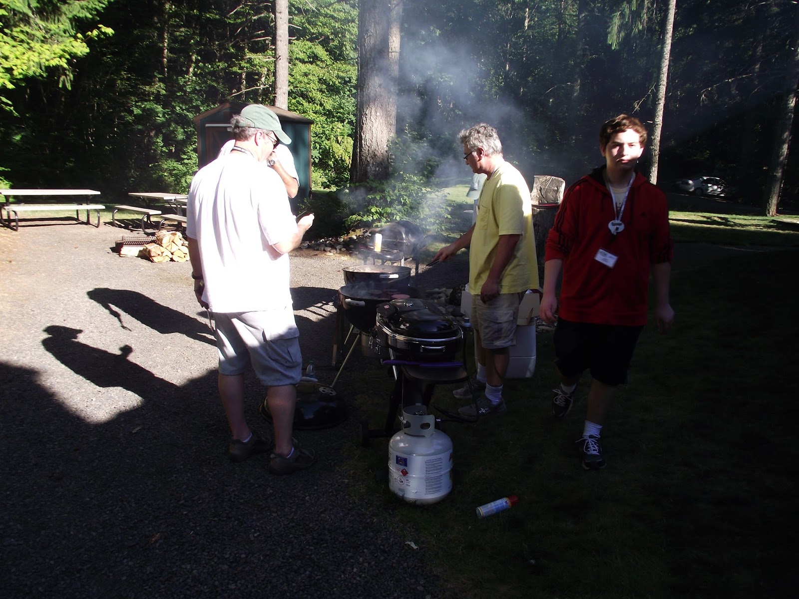
It was getting closer and closer to dinner time.  The grills were fired up, Brenda started putting stuff on the table and everyone added their dish, dessert or goodie to the dinner table.  I felt bad because we didn't bring anything but it turned out we didn't need to because there were so many leftovers.


The WSGA treasurer finally got there so Ben came and got our money for dinner.  We bought a few more raffle tickets for the upcoming raffle drawing.  There were over $500 worth in raffle items.  Brenda and Ray got donations from Cabela's, Walmart and several of the other geocachers.  They even donated their own money for prizes.

It was now 6 and the start of the food frenzy. I grabbed myself a hamburger, some chips, potato salad and a handful of fruit.  We brought our own drinks.

At about 7, is when we had our WSGA meeting.  Brenda opened it up and handed it off to Ben to discuss the Washington State Parks Geotour.  He told us how well it was going and rattled off some impressive overall stats.  I was wowed.  Then Kristine got up and shared some information about the APE event coming up in the middle of August.


And now the raffle.  It took about an hour and a half to finish.  There were so many prizes.  Between mom and I, we had 8 raffle tickets.  We all laughed a lot, tons of jokes and lots of memorable moments.  Just about every caching family/cacher won something.  I came home with a Cabela's multi tool knife.  As soon as we got to the end, some little girl, I don't know who she belonged to, came in out of breath and said there was a kid lighting paper on fire and throwing it into the woods.  Sean immediately got up to check it out.  We really didn't need another forest fire in the area.  About an hour and a half east and north of Goldendale, a raging fire was having its way with the forest.  They actually closed US 97 for a few days and closed Brooks Memorial State Park.  One a lot of cachers were hoping to do this weekend.


It was almost 9, I said goodbye to Brenda and Ray and thanked them for a wonderful campout/event.  We used the bathroom and I grabbed a pop for the road.  We had a long drive ahead of us with two stops along the way.  We got in the car and headed for home.  I plugged home coords into Nuvi and she said we would be home around midnight.

Luckily there wasn't that much traffic heading west on Hwy 14.  We got to our first stop, Washougal.  I needed a cache here for my towns and cities challenge.  We had to go to three places to find a cache that was there.  It was dark so I had to use a flashlight to find one up in a tree.  Got it!  Mom wanted ice cream so we stopped off of Mill Plain at the Dairy Queen.  It took a long time to get my fries (it sounded good at the time, but once I got them about 15 min later, I really didn't feel like them anymore) and mom had already eaten her ice cream when they showed up.  The guy told us sorry for the wait and he gave me more than I ordered because we had to wait for them.  We got back onto 205 and then north on I-5.   When we got off the freeway on exit 88, the moon was very cool.  I think it was a super moon night.

We rolled into our driveway about 12:15 a.m.  It was a fun adventure and I got to talk to friends and make some new ones.

Next Adventure:  Relay for Life

Saturday, July 20

Battle Ground Geocoin Challenge

I got up around 6 and started getting ready for our trip down to Battle Ground.  I got most of my stuff ready the night before so I could sleep in a little longer.  I knew it was going to be hot this afternoon so I wore shorts.  I made some frozen waffles and had some chocolate milk and was all set.  They came down the driveway a few minutes later, I stepped outside and was very disappointed at the weather.  It was cold and misting!  Good thing I was wearing a sweatshirt.

We drove west towards I-5.  They wanted to stop at the 13th Street exit to have breakfast at Denny's.  They had their usual pancakes, eggs and bacon.  They tried to share their extra pancake with me but I opted not to eat them.  I was still full from my waffles.  They finished up, we used the bathroom and then we were on our way down to Battle Ground.

Somewhere between Toledo and the rest stop over by Ridgefield I fell asleep.  It was nice.  I heard Bob turn Ronnie Milsap on during some part of that nap.

Our first stop was the rest stop just before the exit to Battle Ground.  Two years ago, mom and I were down here picking up Erika from the PDX Airport and we stopped here to break the trip up.  At the time there were just two caches here.  We found both of them.  I find myself here again and there is a new one to grab.  I walked with Bob and Bev to grab the ones I already had.  It was actually hard remembering where they were.  They were pretty simple.

We missed an exit that would take us to quite a few but we decided to get on the main highway towards Battle Ground.  The first one we stopped for was at an intersection on a metal box.  It was a magnetic key holder that was hidden pretty well.

After that, we grabbed about four of them off the back roads and some of them were guard rails. A lot of them were the standard micro in the trees and or bushes...there were plenty of these in the Clark County and Portland area.  Then we made our way to Daybreak Park, owned by the county.  The East Fork Lewis River flows though the small park.  I have been here once before a very long time ago with my dad while we visited my aunt, who lives up the road a few miles.  We had a tough time finding the first one until I read the cache page, found it instantly.  The next one was on a picnic table and a guy walked over to us wondering what we were up to.  We told him exactly what we were doing and he thought it was cool and walked back to where his friends were.  We tried looking for another one we couldn't find near a tree down a small trail.  The owner later emailed Bev and told her it was there, just inside a thicket of sticker bushes.


We got back in the car and picked up several guard rail caches.  One was a Battle Ground Toy Box, one was at the Moose Lodge, one was in the woods next to Salmon Creek, one was in someone's front yard, another was at a church and one of our favorites was in a bell next to a church called Quasimodo.  We gave it a favorite point just because.


We grabbed a few more hanging micros in trees and ventured east towards a section of southern Battle Ground, I think it was technically the Bush Prairie area.  That took us to one at a baseball park, that one was up in the crotch of the tree, we found two at the Winco, one of them was tricky.  It totally pointed to the light pole skirt so we looked in the bushes around it.  We almost gave up until I read some of the logs.  I knew exactly where to look for it plus I saw who owned it and knew what to look for.  A hanging micro in the tree.  Then we made it to the other one at the Winco, gave it a few minutes and gave up...there was just too much tree to look through. 

We got onto the busy 503 and headed north towards Battle Ground.  There was also a walking/bike trail along side of it.  Weird thing was, most of the caches along that road (this was a really busy road) were guard rail caches.  Luckily, there were pull offs.  One required Bob and I to run across the highway to the other side to grab a film canister out from the beat up guard rail.  We tried to find them as quick as we could just because we didn't want a cop paying us a visit.  We found it quickly, signed it and ran back across the road to the car.  We stopped for a few others before meeting up at the Chamber of Commerce in the middle of town.

We had to grab five caches in Battle Ground for them to count on our passport.  We made quick work of it.  We found The Hanging Tree, I Hate LPC's #3, $30,000 Wonder (which was a little confusing but we figured it out, see pic below), Dead Horse Lane and Home Sweet House Church.


We had enough time to go and sign in and grab our passports before the event got too full and busy.  I immediately saw Ray and Brenda.  We visited with them for a while.  We found out earlier that the caches for the event published at 9 a.m. this morning.  That meant all of them were found already and we physically had to find each cache's coordinates on the website, via a smart phone.  That took a while.  The hosts did not have them printed on the passports.  We did our query the night before because we were leaving at 6:30 this morning.  There would be no way to put them on our GPS's.  Unless someone else had a Oregon 400t and could technology hump them to us one by one.  


We mingled with everyone else and Bob and Bev decided to look for one down the road along with other people.  No one could find it.  They all came back to the gazebo.  The host got things rolling by saying that he appreciated everyone coming out to participate and he did a few raffle prizes.  No one I knew won.  And everyone was off, some already did them all and headed to the fairgrounds for their coins and the other half started their cache quest.  We ran into several cachers as we collected our caches and codes.  We had a few bumps on our journey.


One of the caches was already missing and the host had no idea he was going to fix it.  Luckily, we only had to get five of the ten new ones to get the coin.  Several were 4-5 miles away from town and we decided not to do those ones.  We did the five closest ones to town.  We grabbed Green Green Green, Community Garden, Tunnel to the Other Side, Welcome to the Village and Rocks Galore.  All of them were pretty easy to find because whenever we arrived someone was always there signing the log book.

We grabbed four more before heading to the fairgrounds.  One called Dorky Park was really hard to find the entrance to.  I found it funny that the real name to the park was Hidden Glen.  It was sure hidden from us!  Haha.  The cache was on the bridge but not where you think it would be.  I ended up finding it by accident.  I took pictures as a souvenir. 


From Dorky Park, we decided we needed to get to the fairgrounds to get our coin.  It was hot outside.  We found a parking spot along the road near the railroad tracks.  We got out and made the short walk to the fairground entrance.  Immediately I saw a life-sized version of Lightning McQueen from Cars.  I HAD to get a picture with it.  We wandered through the booths and found the Chamber of Commerce one.  We said hi and handed her our passports.  We engaged in some small talk and she handed us our coins.  We thanked her and wandered around the fair for a few minutes.  Before we left, we used the bathroom and got a picture with Lightening McQueen!


We walked back the car and went back towards downtown for a few more caches.  One was in plain sight of an old drive through of a bank and the other was inside a small park on a fish sculpture.  Immediately after I found it, signed it and put it back, another couple cachers walked up looking for it.  I told them the container was hard to open because it is a metal rusted container.


We drove a little north of town for a cache called Ouch!!!  I got worried.  I really didn't want any owies.  The parking was at the end of a housing development and while we read the logs, we were in the right place even though it didn't seem like it.  We walked over a hump and into a huge field of clovers.  It was insane!  We followed the small trail to an area of trees and brush.  The tree is what was ouch.  We thought we were looking for a micro but instead it was a regular.  We walked past it at least 6 times before Bob dug it out of the grass.  We signed it, put it back where we found it and made our way back to the car.


We found a few more around the west part of town and came up to one that baffled us on how to get down to it.  We spent some time reading logs and went and parked by the bank.  Bev was going to stay in the car while Bob and I tried to figure out how to get this one.  We walked along the sidewalk and found where people had gone.  I got scratched up by the sticker bushes, I was not happy.  We found the tree the cache was hiding in.  We walked back to the car and my leg was bleeding. 

We started heading home on the 502 towards I-5.  We picked one up at the vet's office and tried to get one up on top of the hill but the road didn't go through like it showed on the GPS.  I hate that when that happens.  However, we got a great view of my favorite mountain in the cascades, Mt. St. Helens.


We were getting to the end of the road and we decided to take 10th Ave north to the east side of Ridgefield, there we grabbed 7 before calling it quits.  There was a bunch of guardrail ones and one near a halibut restaurant.  Then we hit a detour that took us to the free way.


We got on I-5 north and made our way towards home.  We stopped at Taco Time in Kelso for some crispy burritos.  We got home before 9.

Next Adventure:  WSGA Campout at Timberlake Campgrounds along Hwy 14.

Friday, July 12

Washington State Parks Centennial Silver Geocoin

I mailed in my passport on the 4th of July and got it in the mail probably that next Wednesday or Thursday but we didn't get the mail until Friday.  That envelope made my day!


I was 25th to finish the silver coin and my mom was 26th.

On to the next coin challenge!

Wednesday, July 3

Northern Washington State, Peace Arch and Whidbey Island GeoTours

I was exhausted but really excited to go north today.  We rarely venture out north just because of the traffic through Seattle.  We called Grandma the day before and asked if she wanted to go on a day trip towards Canada.  She said sure.  I got everything ready the night before so I could just get up and go.  We decided to take her van just because there was more room and I was higher up and could see better when I drove.  She came over around 7 a.m.

The first state park we set Nuvi to was Saint Edward, over by where Doug used to live when he lived in Shoreline.  Technically, the park was in Kenmore, east of Shoreline.  Traffic was a little slow coming down the hill into downtown.  Along the way I saw this car in front of me that had alligators, lizards and snakes glued to the back of their car.  It definitely set the tone for the day.


When we arrived, we got confused of where we had to go.  There was a college nearby and we ended up there because we missed the turn.  We made a U-turn and got onto park property.  We found a parking spot, from there the cache was about a quarter of a mile away down a set of trails.  Mom and Grandma opted to stay in the car while I went and got it quickly.  I found the right trail and made my way down it.  I got to the cache site and found the odd looking cedar tree and found it tucked away in a hole.  I signed our names, stamped the passports and put it back.  We used the restroom before we drove away.  We found out the building the park was named for used to be a seminary school back in its earlier years.


We made our way back to I-5 and headed north towards Camano Island.  I don't think I've even been to Camano Island...at least from what I can remember.  We got to Snohomish County and followed Nuvi to Hwy 532 to Stanwood.   We noticed a shop we wanted to stop at when we came back through.  It had rooster statues.  We went across the bridge into Island County and made our way to Cama Beach State Park.  We didn't realize that you could access the cache from the road at a trailhead parking.  I really need to read the cache page before we go after caches.  This one wasted some time because I had to walk to it on truck access roads inside the park.  I probably set myself back a few minutes.  When I finally got to the cache site, I tried to call mom to meet me at the spot but spotty cell coverage prevented me from doing so.  I was frustrated because I did not really want to walk back.  I did my cache thing and tried to see if there was another trail that led me to the van, nope, I would have to walk along the road.  I got to the parking lot and the van was gone.  I had no idea where they went.  I got worried.  A few seconds later they drove up.  They said while they were gone, they drove around the place.  I got in and we drove to the next one but with two small pit stops.


One was at the small corner park entering Camano Island and the other was at a place called The Spare Room Flea Market.  Mom wanted one of the roosters.


We made our way to Mount Vernon, near the site of where the bridge collapsed.  We didn't have to go over it to or from Canada.  There was always a different, more efficient, road than I-5.   We got on the 536 west which linked us up with Hwy 20.  We took a side road called Bayview-Edison Road.

Bay View State Park was the next place to visit on the list.  We got back on I-5 via Pioneer Highway that took you right to the park.  I've never been here before. We rolled up, found a place to park, as close as we could get to the cache, and one of the workers drove up next to us on the lawn mower, and asked us if we needed any help. Haha. I told him no, we were here geocaching. He said have fun. Mom and I went over to GZ and found it quickly up inside a metal post, it was magnetic. We signed our names, stamped our passports and put it back better than we found it. We used the restroom and then admired the small cabins nearby before leaving.  On our way to Larrabee State Park on the curvy Hwy 11 aka the historic Chuckanut Drive.


Last time I was here was on a vacation back in Aug '11. We had just finished our first time at Friday Harbor in the San Juans and wanted go to Bellingham for the county and the DeLorme squares. We stopped by Larrabee just to see it. We went to the same parking lot off of Hwy 11 to decide what we needed to do because we were still far away from the cache. Reading the cache page, we noticed where we really needed to go. When we got to the road and it turned into gravel and uphill, we were like...uh is this the right way? It kept going and going and I was like really, it's up here? Grandma had trouble on the very narrow road with a drop off but she stuck through it. We got to the top, they admired the view as I ran down the trail for the cache. I found it right away and after reading some of the logs, it should have taken me a while. I signed our names, stamped our passports and put it back better than I found it. Grandma was very glad to get off of that road and back onto the highway towards civilization.  So far that's been the most insane one we have done.  I sure hope people read the cache page before they start.


We got back onto I-5 and  made our way to Birch Bay State Park off of the side roads. It's too bad I haven't been to this state park either. This one was pretty cool! We drove up to the cache, found it quickly, admired the crane in the swamp nearby, signed our names, stamped our passports, put it back, and then walked across the street to enjoy the beach. We took a few pictures and loved the scenery. There were lots of people at the beach today and the sun was out!


We got on the 548 towards Blaine.  I have never been this far north as far as I can remember.  Mom said when I was an infant we came up here for a vacation one year.

I've always wanted to come up here. I wish I would have had my passport or enhanced driver's license. Maybe next time. When we arrived there really wasn't that many people walking around so we started exploring the place. We took lots of pictures and talked about many of the strange pieces of artwork around the park. We could not believe we could straddle the country line that easily.  I was in Canada and the US at the same time.  I was so excited about it for some reason.  We really liked the Welcome to the United States of America sign.  After looking and wandering around we decided it was time to go find the cache so we could do the rest of the ones we had planned today. We logged our find, stamped our passports and put the cache back better than we found it.


It was dinner time so we found a place in Blaine.  We ate dinner at the Pizza Factory.   We were there for maybe an hour.  Their pizza was good.  We couldn't eat it all so we brought some of it home.

This next section wasn't really in my plans for the day but mom said since we are up here we might as well do Whidbey Island.  We looked at the ferry times for Mukilteo-Clinton in the information center next door.  We took home several brochures and booklets.

We got onto I-5 south and made our way to the Burlington exit for Hwy 20 west towards Anacortes and Deception Pass.  Since the stamp was missing from the state park in Deception Pass, we just went over the bridge for the views.  We continued towards Oak Harbor and the Nuvi turned us down the road just before we got into town.  We got to Joseph Whidbey State Park.

A few years ago we went to Deception Pass, Anacortes and Friday Harbor and sadly ran out of time to explore this part of the island. We approached the parking area and found out there weren't that many people here. We got out and it was chilly and very windy. We all put on jackets and made our way down the hill and to the beach trail. It was a nice walk. I found ground zero and made the find quickly while my other two caching companions caught up to me. We signed the log, stamped our passports and put the cache back in its hidey spot. We enjoyed the walk back to the car, we walked along the beach this time around.  Took a few pictures.  We got to the van and headed down the road and I found out I had a citation underneath my windshield wiper. I stopped, grabbed it and read it before heading to the the next state park. I had forgotten to put my license plate number on my Discovery Pass, hahaha! Luckily, it was a warning because I had a pass. Another story to add to the collection.


We continued going south along the west side of the island to Fort Ebby State Park. We were running out of time and needed this one and one more before the sun went down and the parks closed. I really didn't know what I was in for when I left the van. I ran down the hill the entire way until I reached GZ. I stamped the passports, logged our names and put it back better than I found it. On the way back up I admired the view of the Sound from the one view point and made my way back up the hill to meet up with mom and Grandma who opted to stay in the van. The gas light just came on as we left, we needed to get gas in Coupeville before going to our last park.


We found a gas station in Coupeville and they wanted almost 4 dollars a gallon!  Mom just said to put ten bucks in and that should last us until we get to the main part of Washington.  We got onto Engle Road and finally the last stop of the night and our 50th park, Camp Casey.

I was on a quest to get my 50th state park cache and this is where it was. It was a great park to end on for the evening. The sun was going down...we timed today perfectly. I've never been here before so it was pretty cool to see the light house my mom was so excited to see. We took some pictures before we found the cache. I wanted to make sure my 50th state park cache was documented. We found ground zero and the cache was pretty easy to find. My mom had to look in the worm bin just for fun. We rummaged through the cache and traded some items. We logged our find, stamped our passports and put it back better than we found it, but not before taking the milestone picture first.  We drove to the other parking lot to see the bunkers and guns.  It was almost sunset so we decided to leave before we got locked in.


We decided to pass up South Whidbey State Park since we filled our quota for the day plus it would have been dark.  Maybe another day.

We got back onto Hwy 20 and it turned into the 525 and followed the couture of the island until we got to the ferry in Clinton.  We paid our $9.75 and got in line.  We didn't have to wait long.  A lot of cars got off.  When we got onto the ferry we were one of maybe 12 cars on the load to go across the three mile gap to Mukilteo.  It would be a half hour ferry ride.  We used the restroom and enjoyed the view from the front of the boat.  It was windy.  It was a quick ride.  We got back in the car, it docked and we headed towards I-5.


We stopped at a gas station to fill up and get some snacks.  It was getting pretty late.  The Nuvi said we would get home after midnight.

We got home and Grandma dropped us off.  We ended up driving approximately 446.4 miles.  It was worth the time, the fun experiences and the silver coins we were going to get in the mail in a few days.  Until the next adventure!


Next adventure:  Battle Ground Geocoin Challenge