Friday, March 31

Nevada/Arizona Vacation: Leaving Tucson, 3.2 Mile Hike in the Bulldog Canyon for GC57, In-N-Out and Tempe

I woke up around 7:30 and then decided to lay in bed until about 8.  I knew we had a lot to do and to make the most of our day, I finally got out of bed and got ready.  I used restroom, peeled some of the burnt skin off of my face...it was getting gross, packed up my stuff into my suitcase and set it outside the door in the hallway, for staging.  Mom took a shower and then got ready, and her stuff all packed up. I took the sheets and pillowcases off my bed and pillows, so Lisa didn't have to do it and put the linens into the laundry room.  I did that for Mom's bed too.  I saw that Lisa was outside picking up dog poo.  I went outside to join her and talked about a bunch of random things for about a half hour...mostly about wedding stuff for next summer.  She was excited for us.  I sure hope that their schedule worked with the wedding date so they could come.


Mom and Tony came out to join us, then Tony went back inside the house to start breakfast.  He asked us how we would like our eggs, we said scrambled.  We sat at the table with the Ricon Mountains in the distance and ate scrambled eggs, the rest of the Danish ring from Trader Joe's, bagels, strawberries and chocolate milk.  It was tasty.  We continued chatting for the next hour or two.  Tony showed me his car, the storage in the garage and kitchen (I was super jealous of their house and all the room they had).  They said it was super cheap to retire in Arizona rather than in Washington and it definitely got me thinking of what we were going to do when we reached retirement age.  I saw that our cooler leaked and got my backpack wet and the floor had puddles.  I cleaned it up and stuck my backpack outside to dry in the sun.  We chatted a little bit more as I packed up the rental car.

My backpack kinda dried in the short amount of time it was out there but better than nothing, so I put everything back in it and took it out to the rental car.  I took a couple pictures of their house and a picture of Tony's car because it was cool, and I wanted to show Dad when we got home. 


We said our goodbyes and thanked them for letting us come visit them.  They said we were welcomed back anytime we would just have to let them know when, so they would be home instead of on vacation somewhere.  She said we were great guests, and no one has ever taken their linens off their beds and put them in the laundry room.  I told her I do that just about everywhere I go.  She told us to drive safe and to enjoy the rest of our trip.

We drove through Vail and headed back towards I-10 but first we stopped at the local Safeway for some ice and a couple of drinks.  It was a quick in and out and pulled our cooler from the trunk and piled some crushed ice into it.  We rearranged our drinks and snacks that needed to stay cool and left the parking lot back towards the freeway. We were slowed up waiting for a train to get onto I-10, but we didn't have to wait that long. We merged onto I-10 west and traveled through Tucson.  We didn't get to explore Tucson that much on this trip but maybe next time we visit we can.

Along the way, we chatted about some of our summer plans, Erika and Zac getting married and some other random things including a little bit about the hike we were on our way to.  We followed the GPS to the Chandler/Gilbert exit, which was about 2.5 miles away when all of a sudden, we had to stop.  Why were we stopping?  I couldn't just look at the app on my phone because we were not in Washington.  Apparently, there was a wreck about 6 miles ahead of us.  When we finally got to our exit, I was so glad to be off of I-10.  However, the exit was backed up a bit because of all the people exiting.  We just had to be patient.  

We finally got going and followed the GPS to the Bush Highway via the Usery Mountain Regional Park.  This area was located in the Tonto National Forest, north of Apache Junction, and we were headed to one of the trailheads of the Bulldog Canyon.  We approached the trailhead, parked around 2:00 p.m., and I got out to look at the sign.  It was a permit area, and I chose not to pay the money to have the code to the gate so we could drive to where we needed to be.  We were going to park and walk in even though it was going to be a 3.2-mile hike roundtrip.  I told Mom to grab everything she needed, threw her hiking shoes on and she was sad she didn't have a hat to wear because the Mariner hat was packed away in the suitcase.  We sprayed ourselves down with sunscreen, I put my floppy sunhat and hiking shoes on and off we went up the dirt road.


I was glad we decided to hike in because I really don't think the rental car would have made it up that dirt road.  There were a lot of low spots and I think the car would have had a lot of trouble.  You definitely need a truck or a vehicle with a high clearance.  About a quarter of a mile in, we found an adidas visor someone had lost.  Mom didn't care, she picked it up and wore it, I laughed, but she was glad to have a hat that kept the sun off of her face.  We walked approximately one mile in before we had to make our own trail west out in the cacti, brush and washouts. There was no defined trail but there were caches that lead the way to GC57, which was about 0.6 mile away from the dirt road.  This is where the real adventure began. 

We found the parking coords to the cache, What Shall I Name It? (GC8JC8K) if we had driven a vehicle up the dirt road.  That cache was an indication of where you would start hiking west, like a reference point.  We decided to grab the cache after we were done grabbing the reason why we came out there, the oldest cache in State 48!  

We started heading west off the road to our first cache, West Towards 57 (GC7GJ93) and it was work getting out there because there wasn't a well-defined trail.  You had to walk around brush, cacti, rocks, dips and hills.  The coords were spot on which was nice.  I really didn't want to be wandering around a place that you shouldn't fall on because of all the pointing things that could stab, scrape or impale you.  The container was a soccer tin and had some little trinkets inside.  I just signed the logbook, got my photo and put it back.  

We set the next one up on my phone, Pennies From Heaven (GC480C8) and made the trek out to it, amongst the Saguaros.  It was a nice hike thorough the desert because it was different than hiking out in the trees, forest and brush of the Pacific Northwest. It was a nice change of scenery.  The weather was pretty mild for Arizona this time of year, but it was nice for us who haven't seen sun since last October.  We arrived at ground zero and there were pennies all over the downed dry dead tree.  The container was a plastic ammo can. We got our name on the logbook, got in a photo and put it back under the dead tree.


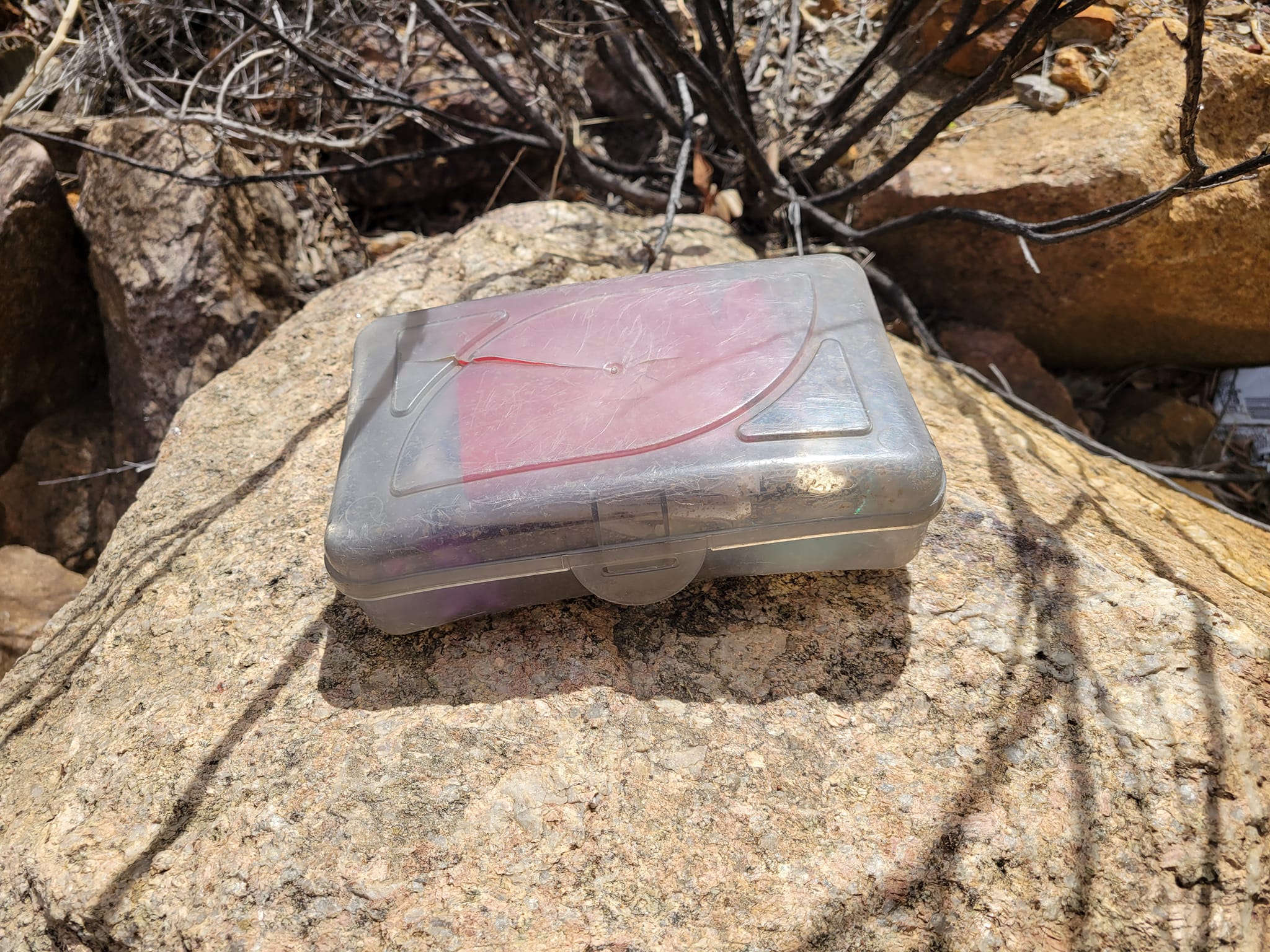
Next, was the main event and I was so excited.  I've gotten the oldest caches in Washington, Oregon, Nevada, Maine and now Arizona!  You can't come to the Phoenix area and not grab GC57.  We got closer and closer, avoiding the scratchy brush and maybe snakes...which you had to keep your eyes peeled for. Nobody has time to be bitten by a snake, especially out in the middle of the desert.  We walked around a large grouping of cacti and brush to see an ammo can hidden by a large pile of rocks.  I could not believe I was at the oldest cache in Arizona.  Years ago, I never thought I would be finding that cache. 

We signed our names, I took several pictures of it, held it and rummaged through the contents.  I did take a travel bug to bring home with me.  I put everything back inside the ammo can and put it back where I found it.  It took a while to stack all the rocks up around it.  I looked at the map and there were a ton more out here, but we didn't have time to wander around.  I used the previous caches to get us back to the dirt road, so we didn't meander off "path" too far.  


It took us a little less than a half hour to get back to the dirt road.  When we got there, we found the cache we saved for the way back, it was a pretty easy grab, signed our names and put it back.  We walked a little more than 500 feet to Looking North (GCN6FF) on top of a pile of rocks with a decaying Saguaro. We signed the log, took a few pictures and put it back.  We made our way back down the road towards the rental car.


We picked up four more caches along the way, We Proceeded On (GCHPWY), Stop and Drop (GC8E7QP), Bob (GC8HNGR) and Kevin 2 (GC8HNGK).  While we walked that mile, I messaged Christin if she was available to meet up for dinner somewhere.  About 20 minutes went by before I heard back from her.  She said that she wasn't available because her sister in laws father passed away all of a sudden and had to leave town with her brother, so Christin was responsible for taking care of her niece and nephew who had just gotten out of school that day.  She said if we were around earlier, she would have been able to hang out.  It was a bummer we weren't able to connect this time around but maybe next time I am in Arizona we can make some plans that will stick.  I chatted with Ben for a little bit while we walked.


We got back to the rental car, and it took us a little bit more than 2 hours to walk 4.1 miles through the desert, found nine caches and Mom got a free hat!  We changed out of our hiking shoes and socks into different shoes, drank some water and then set the GPS to the closest In-N-Out.  It was about 40 miles away in Tempe near the airport.  Unfortunately, when we got there, I took the wrong exit and took us away from where we needed to be.  I just punched in another In-N-Out and that one took us to Baseline Road near the Arizona State campus. 

We pulled in and noticed this In-N-Out wasn't busy.  We got in line, ordered and our food was out in a few minutes.  We got the cheeseburger, fries and strawberry shake just like we did after the Marinier game earlier that week.  It hit the spot after hiking in the desert.  We finished our food, cleaned up, used the restroom and headed out to the closest Walmart.  I wanted some Prickly Pear beer to bring home as a souvenir for my friends and myself to try.  It gets added to the blueberry beer I found before we drove down to Tucson.  My suitcase was going to be heavy.  Yikes!

We set the GPS to the hotel address, and it took us through the ASU campus.  I could not believe how spoiled these kids were!  Literally anything they wanted or needed was across the arterial.  That included every known fast-food joint, a Buffalo Wild Wings, a drive through beer and liquor store, weed, clubs, etc.  WHAT?!  You have to be rich or have a job to go to school here!

We got to our hotel around 7ish and I pulled over to let Mom out to check us in.  She told me where to go and park.  We were in room 132 on the bottom level which was nice.  We had a lot of stuff to bring in and sort through.  

Mom talked to Rhonda for a bit while I chatted with Ben.  I got in a shower; Mom checked us in for our flight and then she got ready and had a quick shower.  We watched Iowa beat North Carolina in women's basketball, I wrote in my journal, organized our suitcases and was disappointed that our phone service and internet sucked.  We were in the middle of Tempe, near ASU, why isn't it working?!

I finally gave up and went to bed around 11 p.m., the next day was going to be a long one.

Some notes on the day:

We walked 16,328 steps which is about 6.5 miles and drove 155 miles in the rental car.

We found nine caches of those nine, all were traditionals and one was the oldest cache in Arizona.  I took care of the 9/2000 square on my Jasmer grid and only have three more to get.

We hiked 4.1 miles in the desert.

My face was peeling so bad, and I learned my lesson the next time I come down here.

I was happy to have In-N-Out one more time before going home.

I will miss the sunshine until summer finally arrives to the Pacific Northwest.

Next Adventure:  Nevada/Arizona Vacation:  Traveling Home from Sunny Arizona to Rainy Seattle

Thursday, March 30

Nevada/Arizona Vacation: Queen Mine Tour, Brewery, Leaving Bisbee, Lisa and Tony's House, Saguaro Corners for Dinner, Hanging Out

Our alarm went off around 7:30, Mom got up to take a shower and I laid in bed for a couple minutes longer.  I eventually got up around 8:00 and started getting ready for the day.  We made sure we had all of our stuff and packed it away in our suitcases and various backpacks and bags.  We ate the rest of our blueberry muffins and bananas for breakfast.  We cleaned up our mess, grabbed the wagons by the gate, piled our bags and luggage inside of them and wheeled them out to the rental car.  We took some pictures of the property and the trailers, made sure the key was left in the door like the instructions told us to and headed out of the Shady Dell and back into Bisbee.


We drove up the hill, past the Lavendar Mine Overlook and into downtown Bisbee.  We got there too early for the mine tour, so we parked near the convention center and decided to walk around for about an hour.  We walked up staircase #2 (98 stairs) while we wandered around town to waste a bit of time.


I also did four waypoints to two Adventure Labs. We saw that it was almost time to head on up to the Copper Queen Mine for our tour.  We walked back to the rental car and drove to the visitor's center.

I got this information from the handout given to me at the visitor's center:

"Bisbee - a name to stir the interest of mining men everywhere - has been the greatest copper camps the world has ever known.  In almost 100 years of continuous production before the Bisbee mines closed in 1975, the local mines produced metals valued at $6.1 billion (at 1975 prices) one of the largest production valuations of all the mining districts in the world.  This staggering amount of wealth came from the estimated production of 8,032,352,000 lbs. of copper, 2,871,786 ounces of gold, 77,162,986 ounces of silver, 304,627,600 lbs. of lead and 371,945,900 lbs. of zinc!

Today's Queen Mine Tour takes visitors deep into the old workings of the famous Queen Mine where great tonnages of extremely rich copper ore were mined in the early days, catching the attention of the mining industry around the world as one of the greatest treasure troves of copper ever discovered.  Taking the Queen Mine tour is the step back through the pages of history.  A melting pot of immigrant miners from the mining districts of Europe labored beneath the Mule Mountains to feed the insatiable demand for copper and electricity.  The electrical age changed the world from a predominately rural society to the industrial age, bringing with it the highest standard of living the world has ever known.

The story of Bisbee mining began in the late 1870's when Lt. Jack Dunn, in charge of a calvary detail from the frontier Army post of Fort Huachuca, was on a scouting mission against the Apache Indians.  Lt. Dunn and his men headed for a spring in the Mule Mountains to camp for the night.  The party camped on a spot fairly flat ground in the canyon below the spring - a site now occupied by Old Bisbee, only several hundred yards from the beginning of today's mine tour.

On a walk after dinner, Lt. Dunn picked up an interesting rock.  He had enough knowledge to geology to recognize the presence of marketable metals, including copper. Unable to follow up on the because of military duties, Dunn took a prospector by the name of George Warren into his confidence and struck up a deal by which Warren would locate claims and work the property with Dunn as a partner.  But on his way to the site, prospector Warren stopped to visit some friends and enjoy his favorite pastime - whiskey drinking.  He soon has new partners, and they staked a new group of claims and left Dunn out of the deal.  When Dunn came along later to check, he was on the outside looking in. 

Copper production began on a limited basis around 1880.  Individuals and then companies with capital gradually became involved and took over individual claims and brought them into production.  Phelps Dodge Corporation, through a subsidiary the Copper Queen Consolidated Mining Company, became the dominant force and eventually the sole operator of the mining district.  Building on its base in Bisbee, Phelps Dodge became one of the largest copper producers in the United States.

Phelps Dodge Corporation closed the Bisbee underground mines in the summer of 1975.  Bisbee Mayor Chuck Eads, with the generous cooperation of Phelps Dodge, brought to reality the idea of opening a mine tour through a portion of the world-famous Copper Queen Mine.  Mayor Eads felt that history of mining should be kept alive in Bisbee and in a manner that would attract tourists to the community.  Many faithful volunteers cleared thousands of tons of fallen rock and re-timbered the old workings.  They were assisted by local individuals and groups who furnishes support and food for the workers.  The local effort came to the attention of a federal agency, the Economic Development Administration, which approved a large grant to the City of Bisbee to help the mine tour project and other improvements in downtown Bisbee designed to aid the tourist business.  The Queen Mine Tour was officially opened to visitors on February 1, 1976.  Since then, more than a million visitors, from all 50 states and more than 30 foreign countries, have enjoyed the ride to into the mountain on the underground mine tour train. 

The Queen Mine Tour ins an authentic mining experience, and the tour guides are all experienced miners, having worked in the local mines for many years, and assure you a safe tour set against at background of factual information." 

We grabbed what we would need and went inside to check in.  We each received an old miner check in tag.  As per the Mine Safety and Health Administration (MSHA) regulations, every mine must maintain a check-in and check-out system to provide a record of who comes in and out of the mine.  The traditional method for this system is a board full of metal identification tags.  Before you enter the mine, you place your metal tag on the board.


We waited over by the "lobby" area until it was our turn to hear the safety rules, a little bit of history and to get our helmet, vest and light.  The group before us was a little later than anticipated, so we had to wait for them to finish their tour.  They finally arrived, dropped off their equipment, some thanked the tour guide and handed him a tip and Mom and I got up so we could be ready to go.

The 10:30 tour gathered around our tour guide. He introduced himself as Neal and that he was an actual miner who mined the tunnels and caverns we were about to see.  He also introduced the historian, Josh, to the group and then continued on with his safety talk. It was pretty straightforward, keep your hands and legs inside the train, do not leave the train while it's going, keep your light on and don't take your helmet off...among other things.  We all got in a line, and he handed us our helmets, vests and lights.  I told Mom that it was so worth doing this tour.  We followed Neal out to the train.


We got onto the small train and waited for Neal's instructions on what he and Josh were going to do before we went inside the mine.  They had to open two shafts, the entrance and the other one a couple 100 feet inside the mine.  They said it was important because of the air pressure inside the mine.  Once we got through the two shaft doors, we puttered down into the mine several hundred more feet before we stopped for our first cavern.


We all got off safely and walked up the wooden stairs to the cavern.  He let us look around for a few minutes before he gathered us all up and told us about the different kinds of mining, minerals and machinery they used over the decades.  Neal knew his stuff and it was fun listening to his information and stories he told us.  We carefully walked down the wooden stairs back onto the train.  


We puttered another couple hundred feet to our next and last destination of our tour.  We dismounted the train and followed Neal to hear about the uses they had for dynamite and the safety of the mines.  He also went over a couple of the old school machinery that has been parked for decades all over that stretch of tunnel. He even showed us an old mobile "porta potty" and some of the funny stories that came to mind. Some of the people on tour asked him some personal questions about when he was a miner in the tunnels.  He said the insurance was so great that when he had his first kid it was all paid for except for a dollar.  He could not believe it!  He literally put a dollar bill into an envelope and sent to the hospital.  That was also in the late 1960's when things were a little bit cheaper too.


It was time to head back to the surface for the next tour.  We hopped onto the train and made our way the end of our tour.  It was fun to watch the minerals sparkle along the carved-out tunnel as we puttered our way up. We stopped twice to pass the two mine shafts with the gates.  When we came to a complete stop, Neal thanked us for attending the mine tour and to exit safely and back into the building where we will be dropping off our vests, helmets, lights and metal tags.

Mom and I went inside and waited our turn to dump off our gear.  We thanked Neal for a great time and Mom gave him a tip.  We used the bathroom, and I went into the gift shop for a couple minutes.  We didn't need anything.  We headed out to the rental car, and I remembered that I had to grab Czar Mine (GC1KJEK).  Mom sat in the rental car while I ran over to the edge of the rocks and found the beat-up container.  I signed our names, got a photo and put it back exactly where I found it.  I hopped into the car and asked Mom where to next?  We decided to go park at the convention center one more time.  We needed to walk through the shop to see if we could find any stickers or postcards before we left Bisbee.

We went into one of the shop's downstairs and found what we were looking for.  I ended up with a couple stickers, a few postcards and Mom bought a set of earrings.  Mom wanted to walk around for a little bit longer, checking out the shops that weren't open the previous day.  We didn't see anything we absolutely needed.  I did want to go to the Old Bisbee Brewery to try the beer I wanted the night before, Copper City Ale.  This beer was first made in Brewery Gulch in 1881. We walked across the street, and I ordered a beer.  We found a place outside to enjoy the sunshine and the ambiance of town.  I drank my beer while we talked about how busy we were going to be in the upcoming months. I finished my beer and Mom wanted to go walk one more of the staircases before we left.  We walked up staircase #1 (73 stairs).  We knew we were not going to make it to all of them but at least we did 5 of the 9.  We found a really cool graffiti wall and an art alley way.


It was approaching early afternoon so we decided that we should probably start heading back up towards Vail to meet back up with Lisa and Tony.  We left town and got back onto Hwy 80 north towards Tombstone, there was lots of traffic near the tunnel due to construction...that took about 10 minutes of our traveling away from us. Once we got into Tombstone, we stopped at the public restroom because I had to pee really bad.  We said farewell to Tombstone and continued our way north to Benson.  We were waved through the "border patrol" once again and I had our GPS set for a cache in Benson that I wanted to get.

It didn't take us long to get to Benson.  I saw where the GPS was going to take us, and I was happy to see it was literally right across the street from the Old Benson Ice Cream Stop.  I got out and ran across the street to grab Thank a Vet (GC1871A).  It was a electrical face plate stuck on an electrical box.  It was an easy grab.  I ran back around the street and met up with Mom to go into the ice cream shop.  We both got strawberry shakes and drank them as we drove to Lisa and Tony's.  The shakes were delicious!


Once we got onto I-10 we headed west, and Mom called Lisa to let her know we were on our way to the house.  She said she would see us there in a while since she was out running errands.  We listened to podcasts and drank our shakes.  When we did get close to our exit, we ran into school traffic in Vail.  We got to her road, and I noticed there was a cache nearby, so I stopped quickly and grabbed the nano cache, Alpha-Mezzo (GC935KA).  I was out and in of the rental car within two minutes.  

We got off the road and onto the driveway, pulled off to the side so we wouldn't be in her way if she came home when we were getting our stuff out.  Turns out, we had great timing and she pulled up just as we were pulling our suitcases out of the trunk. We brought our stuff in, visited for a while, relaxed and we started a load of laundry while we chatted. 

Tony made reservations for Saguaro Corners for dinner at 5:30. He said it wasn't too far from the house.  As time approached, we got ready and hopped into the suburban.  We drove the short distance to the restaurant.  I sat in the front with Tony and Mom and Lisa sat in the back.  I looked at my caching app and saw there was a geocache in the restaurant parking lot!  I would have to get it after dinner.

We went inside, were seated quickly and I ordered a lemonade when we were asked our drink order.  When our waitress came back, I had decided on pulled pork and fries.  Lisa ordered the table a cheesy dip as an appetizer.  We talked about random things and ate our cheesy dip with various vessels, chips, pita breads, etc.  When our food did show up, it was delicious.  Lisa and Tony bought our dinner for us and we thanked them as we left the table to head back to the suburban.  I wandered over to the cache, Vintage Saguaro Corners (GC6H8JV) and I was almost too short to grab this one.  I had to jump a few times and use a stick nearby to pull it towards me.  It was a magnetic nano, so it took a while to sign the log and roll it back up.  Putting it back was easy.  

We drove back to the house.  We moved clothes to the dryer and spent the rest of the evening chatting until bedtime.

I got in a shower, talked to Ben for a little bit, reorganized my suitcase and I wrote in my journal for a while.  I went to bed around 11:30 and it felt nice.  

Some notes on the day:

We walked 10,100 steps which is about four miles and drove 88 miles in the rental car.
10,100 steps

We found eight caches of those eight, four were waypoints to two Adventure Labs and four traditional caches.

My first time inside of a mine and got to meet an actual miner who worked in the Queen Mine.

Had a strawberry milkshake at the same ice cream shop that Mom and Dad went to back in 2019.

We got to spend the night inside of a 1950's trailer instead of a hotel.

Next Adventure:  Nevada/Arizona Vacation:  Leaving Tucson, 3.2 Mile Hike in the Bulldog Canyon for GC57, In-N-Out and Tempe