We packed our stuff in the car and headed out to get the one we didn't get yet. It was at Crown Point State Park. A place you could park your car and watch and listen to the laser show from your radio. It was a great view of the town. We grabbed the cache and took pictures.
We drove east to grab one kinda off of our path for a DeLorme square, page 38. The view of Roosevelt Lake was pretty spectacular from this spot. We picked up a bunch of aluminum cans.
We got back into the car and headed towards Electric City. We were on our own today because Steve and Tammy were going to head east to visit with friends for another few days. We assumed we would see them at another event soon.
We were told to see this virtual from some other cachers. I love weird stuff like this off the road.
From here we headed to Banks Lake along the Coulee Corridor Scenic Byway/Hwy 155. Due to the fact that it was so dry this summer, there hardly was any water in the lake. When we were looking for places to camp, they told us to stay away from Banks Lake because it smelled like dead. We did stop along the way to pick up a few caches here and there, one was an earthcache called Devil's Punchbowl, near Steamboat Rock.
We drove further along the highway stopping at most of the caches along the highway because there really wasn't that many. I remember two of them giving us a really hard time. We started getting higher and higher up on the coulees. I knew we were getting closer to Dry Falls. We picked up a few more before going to Dry Falls.
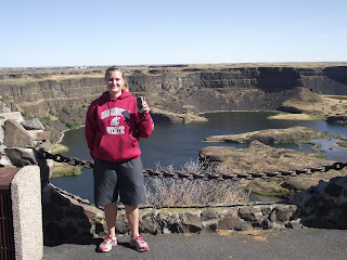
Once we got to Dry Falls I was stoked. I have not been here since I was in middle school and I loved it the first time. During my geology classes, we learned a lot about this area and the glacial :ake Missoula floods from a long time ago. This scar, is a result of that flood.
Some more info on Glacial Lake Missoula and the Flood:
Nearly twenty thousand years ago, as glaciers moved south, an ice sheet dammed the Clark Fork River near Sandpoint, Idaho. Consequently, a significant portion of western Montana flooded, forming the gigantic Lake Missoula. About the same time, Glacial Lake Columbia was formed on the ice-dammed Columbia River behind the Okanogan lobe of the Cordilleran Ice Sheet. Lake Columbia's overflow – the diverted Columbia River – drained first through Moses Coulee and as the ice dam grew, later through the Grand Coulee.
Eventually, water in lake Missoula rose high enough to float the ice dam until it gave way, and a portion of this cataclysmic flood spilled into Glacial Lake Columbia, and then down the Grand Coulee. It is generally accepted that this process of ice-damming of the Clark Fork, refilling of Lake Missoula and subsequent cataclysmic flooding happened dozens of times over the years of the last Ice Age.
This sudden flood put parts of Idaho, Washington, and Oregon under hundreds of feet of water in just a few days. These extraordinary floods greatly enlarged the Grand Coulee and Dry Falls in a short period. The large plunge pools at the base of Dry Falls were created by these floods.
Once the ice sheet that obstructed the Columbia melted, the river returned to its normal course, leaving the Grand Coulee and the falls dry. Today, this massive cliff can be viewed from the Dry Falls Interpretive Center, part of Sun Lakes State Park, and located on Route 17 near the town of Coulee City. Admission is free however a Discover Pass is required for parking; 5$ a day or 30$ for the year.
Before we left the parking lot, I made some PBJ sandwiches and we had Cheetos and Doritos with a cold Pepsi for lunch. It was delicious.
We continued south along Hwy 17 towards Soap Lake. We could only get a few more caches along this road because it was getting late and we needed to get home at a certain time. We grabbed a few more before getting to the lake. I would have smothered mud all over me if we had the time to do so. The earthcache here, required us to play in the mud and analyze the water.
The mud was wonderful. This lake as well as Omak Lake were both soapy, due to the minerals mixed in with the water. It was suppose to be good for your skin and such. We cleaned ourselves off and went to the next one, which took us into Moses Lake. We got a few there and merged onto I-90 towards home.
We made a few more stops, one was the rest area along the Columbia River near the Vantage Horses and the other was at the top of the hill at the Rye Grass Rest Area, where we grabbed a puzzle cache by ohjoy, it had to do with the windmills.
We got home around 9 p.m. that evening and I packed my stuff in the car and went home.
Next Adventure: WSU Cougars vs. Oregon State Beavers, Seattle, Wash.


No comments:
Post a Comment