Monday, September 19

Electric City, Dry Falls and Soap Lake

We got up, used the facilities and started taking the tent down.  The couple beside us were coming back from a road trip from Chicago.  They were from Oregon and had a custom made travel trailer made for them.  They were pretty proud of it.  They even let us look at the inside.  It was pretty roomy for how small it actually was.  Pretty impressive.

We packed our stuff in the car and headed out to get the one we didn't get yet.  It was at Crown Point State Park.  A place you could park your car and watch and listen to the laser show from your radio.  It was a great view of the town.  We grabbed the cache and took pictures.


We drove east to grab one kinda off of our path for a DeLorme square, page 38.  The view of Roosevelt Lake was pretty spectacular from this spot.  We picked up a bunch of aluminum cans.


We got back into the car and headed towards Electric City.  We were on our own today because Steve and Tammy were going to head east to visit with friends for another few days.  We assumed we would see them at another event soon.

We were told to see this virtual from some other cachers.  I love weird stuff like this off the road.


From here we headed to Banks Lake along the Coulee Corridor Scenic Byway/Hwy 155.  Due to the fact that it was so dry this summer, there hardly was any water in the lake.  When we were looking for places to camp, they told us to stay away from Banks Lake because it smelled like dead.   We did stop along the way to pick up a few caches here and there, one was an earthcache called Devil's Punchbowl, near Steamboat Rock.


We drove further along the highway stopping at most of the caches along the highway because there really wasn't that many.  I remember two of them giving us a really hard time.  We started getting higher and higher up on the coulees.  I knew we were getting closer to Dry Falls.  We picked  up a few more before going to Dry Falls.

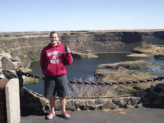
Once we got to Dry Falls I was stoked.  I have not been here since I was in middle school and I loved it the first time.  During my geology classes, we learned a lot about this area and the glacial :ake Missoula floods from a long time ago.  This scar, is a result of that flood.


Some more info on Glacial Lake Missoula and the Flood:

Dry Falls is a 3.5 mile long scalloped precipice in central Washington, on the opposite side of the Upper Grand Coulee from the Columbia River, and at the head of the Lower Grand Coulee. Ten times the size of Niagara, Dry Falls is thought to be the greatest known waterfall that ever existed. According to the current geological model, catastrophic flooding channeled water at 65 miles per hour through the Upper Grand Coulee and over this 400-foot (120 m) rock face at the end of the last ice age. At this time, it is estimated that the flow of the falls was ten times the current flow of all the rivers in the world combined.

Nearly twenty thousand years ago, as glaciers moved south, an ice sheet dammed the Clark Fork River near Sandpoint, Idaho. Consequently, a significant portion of western Montana flooded, forming the gigantic Lake Missoula. About the same time, Glacial Lake Columbia was formed on the ice-dammed Columbia River behind the Okanogan lobe of the Cordilleran Ice Sheet. Lake Columbia's overflow – the diverted Columbia River – drained first through Moses Coulee and as the ice dam grew, later through the Grand Coulee.

Eventually, water in lake Missoula rose high enough to float the ice dam until it gave way, and a portion of this cataclysmic flood spilled into Glacial Lake Columbia, and then down the Grand Coulee. It is generally accepted that this process of ice-damming of the Clark Fork, refilling of Lake Missoula and subsequent cataclysmic flooding happened dozens of times over the years of the last Ice Age.


This sudden flood put parts of Idaho, Washington, and Oregon under hundreds of feet of water in just a few days. These extraordinary floods greatly enlarged the Grand Coulee and Dry Falls in a short period. The large plunge pools at the base of Dry Falls were created by these floods.

Once the ice sheet that obstructed the Columbia melted, the river returned to its normal course, leaving the Grand Coulee and the falls dry. Today, this massive cliff can be viewed from the Dry Falls Interpretive Center, part of Sun Lakes State Park, and located on Route 17 near the town of Coulee City. Admission is free however a Discover Pass is required for parking; 5$ a day or 30$ for the year.


Before we left the parking lot, I made some PBJ sandwiches and we had Cheetos and Doritos with a cold Pepsi for lunch.  It was delicious.

We continued south along Hwy 17 towards Soap Lake.  We could only get a few more caches along this road because it was getting late and we needed to get home at a certain time.  We grabbed a few more before getting to the lake.  I would have smothered mud all over me if we had the time to do so.  The earthcache here, required us to play in the mud and analyze the water.


The mud was wonderful.  This lake as well as Omak Lake were both soapy, due to the minerals mixed in with the water.  It was suppose to be good for your skin and such.  We cleaned ourselves off and went to the next one, which took us into Moses Lake.  We got a few there and merged onto I-90 towards home.

We made a few more stops, one was the rest area along the Columbia River near the Vantage Horses and the other was at the top of the hill at the Rye Grass Rest Area, where we grabbed a puzzle cache by ohjoy, it had to do with the windmills.


We got home around 9 p.m. that evening and I packed my stuff in the car and went home.

Next Adventure:   WSU Cougars vs. Oregon State Beavers, Seattle, Wash.

Sunday, September 18

Omak Lake and Grand Coulee Dam

The next morning I went to use the bathroom and they tried to confront us.  I told them I could not and to talk to Derek.  I would have punched one of them, plus I had to poop really bad so I had to hurry.  The guy walked over to our cabin and talked to Derek.  He said that he though his uncle was renting the cabin next to them and that was his container with fire making stuff inside.  Derek basically said, still you should have asked and not assumed it was yours to take.  He said that he and his friend were sorry and he gave us back the rest of it.  We packed up our stuff and checked out.  We told the lady at the front desk what had happened and she gave us free firewood and a new fire clicker.  I told her I appreciated it and she said that she appreciated us telling her about the incident so next time it will not happen.

We got a hold of Steve and Tammy and they were on their way to Okanogan to get their tire fixed and said that it would be about an hour.  We decided to get the one DeLorme Square that people said would count but we weren't sure based on the map we had.  We went with it.  I found it after about five minutes of searching.


We drove to Okanogan to meet up with Steve and Tammy at Walmart.  We went inside to use the restroom, we got a few snacks and walked around while we waited for the tire to get fixed.  Steve and Tammy were going to follow us to Grand Coulee.  When we left, we saw Brad and his family in the parking lot.  We chatted for a bit.  Steve and Tammy got their car stuff taken care of and we were off to Omak Lake via Omak Lake Road/Columbia River Road.  But first we stopped by the famous Omak Stampede Suicide Race stadium/hill.

Here is more information about the hill and race:

The Suicide Race, also promoted as the World Famous Suicide Race, is a horse race held every year, during the second week of August, in Omak, Washington as a part of the Omak Stampede, a rodeo. Held for more than 70 years, the race is known for the portion of the race where horses and riders run down Suicide Hill, a 62-degree slope that runs for 225 feet (69 m) to the Okanogan River.  Though the race was inspired by Indian endurance races, the actual Omak race was the 1935 brainchild of a local Omak business owner. The race has provoked serious concerns among animal welfare and animals rights groups.


We walked back to our cars and headed to the lake. 

The lake was beautiful.


We went to the famous Erratic Behavior (GCQWV6) and climbed up the insanely steep hill.  It was worth the climb.


It was pretty cool since I have an interest in geology and earth science.  We spent a few minutes taking pictures and examining the rock before we went and got the actual cache, which was about 500 feet from the rock formation.


We drove down to the lake and did some wading.  The water felt soapy because of the minerals that make up the rocks that surround it.


The lake felt so nice on a hot day.  It was really shallow and you had to walk further in a ways to even reach the deep parts.  We walked out to the island and then decided to go and head to Grand Coulee, grabbing the deLorme squares as we went.


We got to the dam and went to the visitor's center to find out when the times were for the dam tour and to find out when the laser show began.  We rushed to where we had to be for the tour because one was starting up soon.  We parked, got rid of all of our things that might pose as a terrorist weapon (pens, pocket knives, etc) and stood in line to get in.  It was a free, first come first served basis.  We went inside the building and listened to the tour guides.  We were loaded up into two vans and taken to the first part of the tour, the inside of the dam.


The tour guide rattled off lots of facts, statistics, history and stories while on our forty five minute tour of inside the dam.  The guy knew his stuff.

We were loaded into the vans again but this time they took us to the other end of town to take us on the outside of the dam tour.  We were literally on top of the Grand Coulee Dam.  The views were amazing.


Some info about the dam:

Grand Coulee Dam is a gravity dam on the Columbia River in the U.S. state of Washington built to produce hydroelectric power and provide irrigation. It was constructed between 1933 and 1942, originally with two power plants. A third power station was completed in 1974 to increase its energy production. It is the largest electric power-producing facility in the United States and one of the largest concrete structures in the world.  It generates 21 billion kilowatt-hours annually.

They loaded us back into the vans and took us back across town and to our vehicles.  They thanked us for visiting the dam.  Steve, Tammy, Derek and I were starving so we went to the R&A Cafe and had their famous Dam Burgers.  Afterwards we cached the town until we had to go check into our campsite before the laser show began.


We drove up the hill and got onto Hwy 174 to the Grand Coulee RV Park.  He went inside to talk to the man and we got our tent spot on the grass.  We put most of it together in the dark with flashlights.  We got everything set up and by about that time it was time to head back down to the dam for the laser show.  This was my first time with the laser show.  I brought some snacks and a drink with me just in case.


It basically took us on a historical tour of how the Columbia River and the dam came to be and how it has influenced the area with its electricity, the wildlife, the people, the Native Americans etc.  The first ten minutes of the show was all about the Columbia River, speaking in first person..."I am the mighty Columbia, I bring life to all..."

Columbia River you are very conceited, lol.

Laser show information:  http://www.usbr.gov/pn/grandcoulee/gcvc/laser.html

Steve and Tammy went back to their hotel and we went back up the hill to our tent.  I took a quick shower and got ready for bed and then used the internet for a while.

During the night a mouse tried to climb up our tent.  You could hear the scratching and see the silhouette of the mouse slide down the side of the tent.  A little while later, it started sprinkling and we got to see some flashes of lightening.  

Next Adventure:  Electric City, Dry Falls, Soap Lake...

Saturday, September 17

Omak/Methow Valley Cache Machine

After all the fun we had at the Portland cache machine we were already stoked for the next one in an area I've never really explored.  I've been through there but I don't remember being there.  The days before I washed laundry, grocery shopped and spent some time deciding what I was going to bring with me.  It was September and I know the weather could do just about everything.  I needed to be prepared.  I brought clothes to keep me warm and I brought clothes for the hot weather.  I was hoping for some hot weather.

About a month ago, I tried getting my enhanced driver's license so we could go to Canada and while up there, visit Lauren in Kelowna.  Because I do not have a physical address I get mail sent to, technically I don't reside at a physical address.  It was on my driver's license, issued by the DMV/DOL, but it didn't count.  I had to have two pieces (I had one) of evidence of my physical address.  I couldn't come up with anything.  I spent two hours wasting my time because I thought I had everything I needed.   I was angry, very angry.

I worked that morning so as usual, I was exhausted but had to get motivated to get all my stuff ready to go.  I drove over to Lacey and packed my stuff in to Derek's car.  We got off to a late start but we hoped we would not get stuck in traffic.  We headed up I-5, got off at Hwy 18 and onto I-90 through Snoqualmie Pass, there we stopped for caches.  We made it to Ellensburg and got off at US-97 and went north towards Wenatchee.  We stopped for a few caches along the way up.


We got a few DeLorme squares as we traveled into uncharted areas, lol.  It was getting dark as we reached the Chelan/Pateros/Brewster area.  We had booked a camping spot for two nights at the Twisp KOA and we had no idea if we were going to be too late to check in.  We rolled in around 8-9 p.m. and it was dark.  Good thing I know how to set up a tent in the dark.  We talked with the lady in charge, she gave us some information about the area and a map and told us where we were going.  We got back in the car and headed to our campsite.  I started unpacking the car and my stomach dropped.  We forgot the tent.  I remember looking at it in the back of my car and thought I had grabbed it along with my sleeping pad. 

What were we going to do?!  I was so mad at myself I think I actually said the eff word without realizing it.

We thought about moving the stuff to the front seat and sleeping in the back of the car.  We had too much stuff and some of it would have to sit outside over night.  I didn't like that idea because I don't trust people.  People like stealing things.  Then we drove to the nearest store to ask if they had tents for sale or to rent.

None.

Crap, what are we going to do?

We went back to the KOA and went and saw the lady at the front desk again.  We told her our issue and she let us upgrade to a cabin instead. We were very lucky there were still some left to rent. We just had too much stuff to sleep in the car.  We drove to our new campsite and it was comfy.  It was almost similar to the ones we stayed at in Anacortes back in August.  We unloaded the car as quick as we could just because it was getting late and we had to get up really early for the cache machine.

I left my bin of firewood, kindling, logs, newspaper and a lighter on the front porch.  You would think no one would mess with it right?

My alarm went off way too early.  I think it was about 4:45-5:00.  I rolled out of bed, got my clothes on, I dressed in layers, nights are cold, days are hot, got my caching stuff together, made sure we had our food, locked the door and drove to the first cache, in downtown Winthrop.


It actually had a really cool downtown, almost like a wild wild west motif.  I felt like I needed to be wearing a cowboy hat, boots and walking my horse down the road.

We waited until a bunch of other cachers met up at the first one.  We waited for Steve and Tammy, our buddies from Hillsboro, Oregon.  We were going to do the cache machine together, like we have for the past two we've done.

We were told this one would cover a lot of ground and would cover more time than the day had allotted.  We even found out from someone that there was a ridge that only trucks and SUV's could do, so we decided as a group to skip those ones.

The first few caches took us around the recreation part of Winthrop.  We found a few near a large pond.  That was quite the walk for that early in the morning.


There were a lot of horse trails, hiking trails and in the winter time they were used as ski and snowmobile trails.  We had to walk down a few of them and drive down some of them without getting lost.  While getting one in particular, we had to turn around because we took the wrong road.  That set us back.  Once we figured out where we needed to be, we saw some other cachers parked at the parking coords.  We had to climb up a hill.  I huffed and puffed.  Once at the cache, we found out there was a road that took us right to the cache.  Lame.  There were great views from the parking area.


We drove out of the recreation area and back onto the main road and headed East on Hwy 20 towards the merge onto Hwy 97 to Okanogan.  I have never been here before but have heard stories from my friend Brenna while at WSU, she is from Omak, which is the town nearby.  Due to the route on the cache machine booklet we printed, we by-passed Okanogan and Omak for the way back.  We stopped in Riverside for a few.  That was the most northeast we were going to go.


On the way back through Omak, even ran into Frisbeer and RL Painter while running around town.  We briefly chatted and moved on to the next set of them.  This was about lunch time so I busted out the PBJ sandwiches and Doritos.


The route took us along the road, up on the hill overlooking the town and next to huge cliffs.   Many of the caches in town were guardrails and caches hidden in piles of rocks.  While driving around town we listened to the Cougar football game at San Diego State.  We lost 42-24.  Ouch.  We still wore our colors proudly.  I sure hope Cougar football gets better.  It's painful to watch and/or listen to the games.

The next bunch took us back through Winthrop and west towards Mazama on State Route 20.  These caches required lots of driving up hills.  We stopped by one on the route that required you to walk underneath the highway through a tube.  It was called Afraid of the Dark?  It was pretty cool.


We drove further up the road and to a dirt road that took us up a very large hill.  There were tons of switch backs but the views were awesome.  It was dry so lots and lots of dust and potholes.   We really had to be careful because both parties had really low clearance vehicles.

 
 It was getting late.  You can kinda feel evening as it approaches.   We drove down the hill and took another dirt road to the left and there were lots of cabins and places for skiing.   We got a little bit further down the road and pulled over for a cache.  On the way back to the cars, Steve and Tammy were surprised with a flat tire.  What bad luck.  We helped them put their spare tire on and headed back into Winthrop.


On the way, we called a pizza place in town because none of us felt like Mexican food at the cache machine dinner.  Steve tried calling a place that would fix their tire.  No one was available.  He found out he and Tammy would have to drive to Okanogan in the morning to get it fixed at the Walmart.

We got to the dinner and signed the logbook.  We wandered around the restaurant and talked to the people we knew and tried to sell coins.  We talked to Painter and Frisbee'r for a while.  We found out that they had to drive back to Olympia that night because Painter had to work the next day.  Yikes!  What a drive they have ahead of them.


 We stayed for a little while and walked around town, went into the gift shop and to the car.  We told Steve and Tammy we would be in touch with them later on that evening.  We went back to our cabin.  We rolled  up and I did not see my container with the newspaper, wood, fire clicker and kindling on our porch.

"Someone stole my fire making bin!"

I was pissed!

Who would steal from someone else's campsite?  We looked around.  The noisy neighbors to our left were having a drunken campfire and I saw the container I brought was in their possession.  I went over there and told them that it wasn't theirs.  Derek told them they were immature because they stole from someone else.  We just let it go for the night, it was late.  We used the restroom, showered, and got ready for tomorrow.  We took some time to log some of our finds from the day.  Then passed out because today was a long day.

Next Adventure:  Omak Lake and Grand Coulee Dam